For centuries humans have been changing the appearance of Schiermonnikoog. Outside the village and the Banck’s polder the landscape by and large has not been made and classified by people, but several cultural-historical elements still refer to the past. The most important ones are listed below.
Old sea dike
Between the Bank van Banck and the Westerburenweg there still lies a dike that was the main water barrier until 1962. This dike was built when in 1860 under supervision of the erstwhile owner of the island, mr. J.E. Banck, the salt marsh was closed off form the sea and the Banck’s polder came into being. Nowadays you can take a nice walk over this dike and enjoy the view on the polder and the Westerplas.
Stone pole
At the highest point of the Minne Onnespad, along the Striedieken, stands the so called ‘Elstienen pail’. Hidden in the reed in the northwestern part of the Westerplas there is another identical, almost forgotten pole. The poles marked the boundary between the property of the Dutch state and the property of the erstwhile private owners of Schiermonnikoog. The history of these poles goes back to the sale of the island by the Stachouwer family to mr. J.E. Banck in 1858. The poles were places after a correspondence of many years between the erstwhile owners of Schiermonnikoog and the Dutch state.
Old paths
Since the shell paths were made in the dunes old walking and driving paths have become obsolete. Most of these paths now have been overgrown by shrubbery. Often the old paths were marked with a granite pole that was marked NK. It is told that some inhabitants of the island were not allowed to enter the dunes because of poaching. They had to stay on these signposted paths.
Bunkers
The bunker Wassermann was built during the Second World War, 1940-1945, on a dune that was known in those years as ‘Wytdun en Poemelsdun’. Nowadays it is called the ‘Bunkerduin’. The bunker offers a great point of view from where you can see the island, the North Sea and the Wadden Sea. A couple of years ago the bunker has been made accessible for visitors. You can look inside if you want. Remnants of other bunkers from WWII are also found elsewhere on the island, e.g. along the Westerhofpad and in the ‘village’ Schlei at De Marlijn. Not all bunkers are accessible.
Cemetery Vredenhof, sailors’ graves and the Reddingsweg
These three elements have a common background. In the past stranded corpses were buried in the dunes bordering the sea. When the tide was extremely high, due to a storm, it could happen that these corpses were flushed out again. In that case, they were reburied behind the first row of dunes, like the dunes to the northeast of the pine forest Tweede Dennen, also called the Lyke dune (‘Corpse dunes’). This laid the foundation for Vredenhof; south of Vredenhof you can find the graves of the crew of a Swedish sailing ship (probably the barque Ruta, which perished in 1863). The unpaved Reddingsweg, which leads to Vredenhof and to the beach at pole 7, was constructed after 1829, to drive the rescue boat to the northern and eastern parts of the beach.
Planted coniferous woods
The coniferous woods on Schiermonnikoog were planted from about 1915 onward, commissioned by the owner of the island, the German count Von Bernstorff. The woods mainly consist of Corsican and Austrian pines. They were planted as production forest, with the intention of harvesting the wood. But they were also meant to end the sand drifting in het dunes on the northside of the village. In the end, the trees have never been felled. Storms have caused large clearings though, where mainly deciduous trees are filling the open space. Since 1995 Natuurmonumenten is working on a transition to more varied woods. Over time, most pine trees will disappear and be replaced with deciduous trees, like birches, alders, and oak trees.
Herdershut and Kweldershok
On the eastern side of the Banck’s polder the Herdershut nowadays accommodates students, PhD’s, and personnel of the Faculty of Biology from the University of Groningen. Its name reminds us of the grazing of the salt marshes by a herd of cows, until 1959. Because of the lack of fresh water on the salt marshes, in het evening the cows returned with their shepherd to this part of the polder, which is still known as the ‘kweldershok’. The relief of this terrain is relatively undisturbed.
Duck decoy
The duck decoy (‘Eendenkooi’) was built in 1861, commissioned by mr. J.E. Banck, after the completion of the Wadden Sea dyke. Until 1959 the decoy was used to catch ducks. In 1959 the Dienst der Domeinen, a body of the Dutch government, ended the leasehold by decoyman IJ. Talsma. The decoy fell into disrepair, but attentive islanders registered the duck decoy anew; in this way they prevented the right of delimitation to become obsolete. After the founding of the National Park plans were made to restore the decoy. The restoration was completed on November 8, 1990. Th. Talsma since then is the new decoyman.
Now the decoy is used for catching ducks for ring trials. Excursions to the decoy are organized on a regular basis.
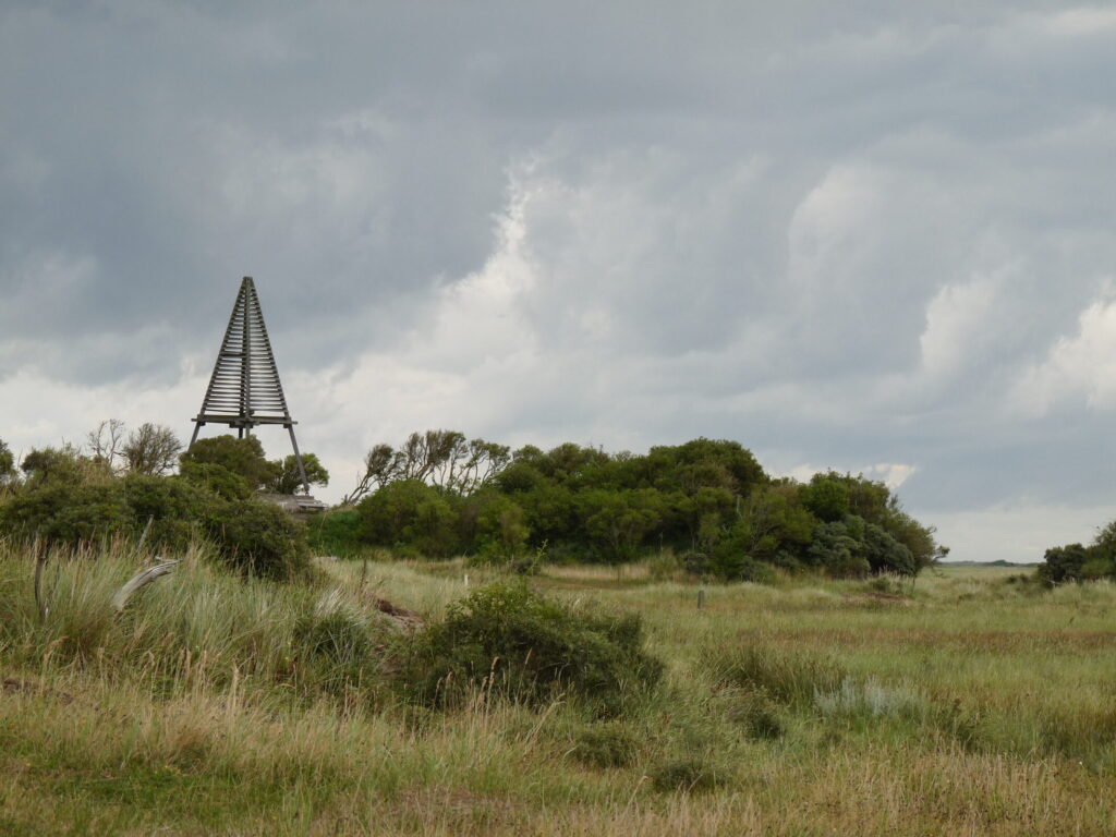
Beacons Kobbeduinen and Willemsduin
In het past, beacons such as these were built as reference points for sailors and for triangulation by map makers. Nowadays, these functions have gone lost, but still these beacons are landmarks in the vast landscape of Schiermonnikoog. Natuurmonumenten maintains both beacons.
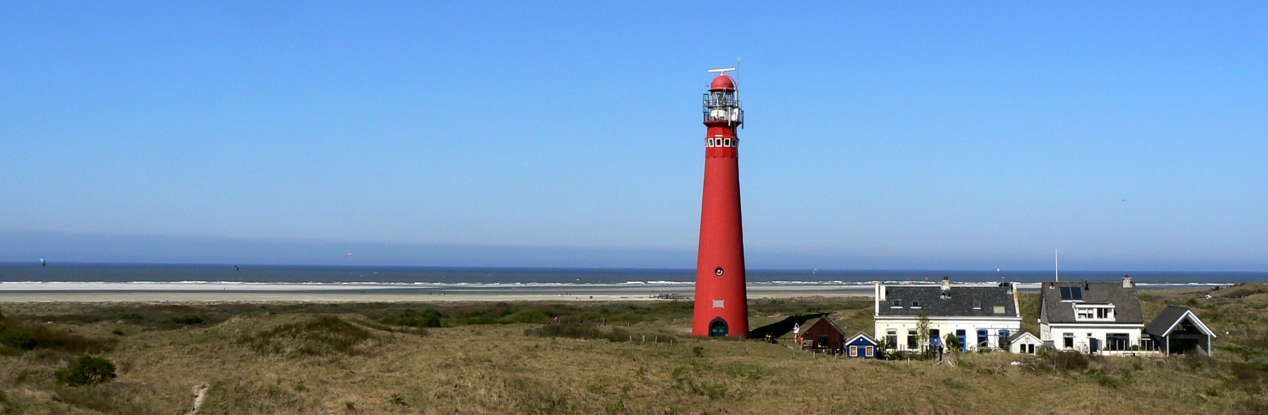
Northern and southern lighthouse
Both lighthouses were taken into operation in 1854. In 1909 the light of the southern lighthouse was extinguished. In that year, the northern lighthouse got electricity and its own characteristic, which made Schiermonnikoog discernible from its neighbouring islands. From 1950 to 1992 the southern lighthouse has functioned as a water tower. In 1998 it was sold to KPN for use in telecommunications. The northern lighthouse is still functioning and occupied 24/7. Both lighthouses have a monumental status.
Stuifdijk
By planting marram grass, the sea strip from the Westerplas to pole 10 has been transformed into a sand dike. The eastern part, between poles 7 and 10, was built in the 1950’s. There have been plans to prolong this sand dike to pole 16, on the far eastern side of the island, as part of the impoldering of the Wadden Sea. But the completion of the ‘stuifdijk’ never succeeded and efforts were suspended in the 1970’s. In the 1980’s maintenance of the sand dike was suspended as well. The stuifdijk still reminds us of the arduous work of a lot of islanders and of the time that we had a different view of coastal defence.